


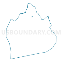
Voting District 5400010, Kings County, New York
About
Outline

Summary
| Unique Area Identifier | 628102 |
| Name | Voting District 5400010 |
| County | Kings County |
| State | New York |
| Area (square miles) | 0.02 |
| Land Area (square miles) | 0.02 |
| Water Area (square miles) | 0.00 |
| % of Land Area | 100.00 |
| % of Water Area | 0.00 |
| Latitude of the Internal Point | 40.69349030 |
| Longtitude of the Internal Point | -73.94058000 |
Maps

Graphs
Select a template below for downloading or customizing gragh for Voting District 5400010, Kings County, New York


Neighbors
Neighoring Voting District (by Name) Neighboring Voting District on the Map
- Voting District 5400007, Kings County, NY
- Voting District 5400009, Kings County, NY
- Voting District 5400013, Kings County, NY
- Voting District 5400014, Kings County, NY
- Voting District 5400016, Kings County, NY
- Voting District 5400017, Kings County, NY
- Voting District 5400018, Kings County, NY
- Voting District 5600097, Kings County, NY
- Voting District 5600106, Kings County, NY
Top 10 Neighboring County Subdivision (by Population) Neighboring County Subdivision on the Map
Top 10 Neighboring Place (by Population) Neighboring Place on the Map
Top 10 Neighboring Unified School District (by Population) Neighboring Unified School District on the Map
Top 10 Neighboring State Legislative District Lower Chamber (by Population) Neighboring State Legislative District Lower Chamber on the Map
Top 10 Neighboring State Legislative District Upper Chamber (by Population) Neighboring State Legislative District Upper Chamber on the Map
Top 10 Neighboring 111th Congressional District (by Population) Neighboring 111th Congressional District on the Map
Top 10 Neighboring Census Tract (by Population) Neighboring Census Tract on the Map
- Census Tract 261, Kings County, NY (4,917)
- Census Tract 281, Kings County, NY (4,193)
- Census Tract 283, Kings County, NY (4,097)
- Census Tract 289, Kings County, NY (3,538)
- Census Tract 287, Kings County, NY (2,991)